 |
| Primula caveana on the Bimbi La, Tibet by Anne Chambers |
Besides viewing this data as a flat map, you can tilt the perspective to see the area in 3D. You can "stand" on a pass and look into the distance and see the peaks as you would on a clear day, just like perhaps George Sherriff did. How cool is that?! If you are a computer geek like me, you will soon want to capture a route as a video, swooping down valleys and soaring over passes as if you can fly through the air. With the free version of Google Earth, there was no ability to capture video. You needed the Pro version which cost about $400US. Now Google has released the Pro version for free.
Download the software on Google using your email address and the key GEPFREE. Even though it may say trial version, it isn't.
The video is one I just created with Google Earth Pro. The white line is the approximate route travelled by Ludlow & Sherriff in 1933 from Singye Dzong over the Kang La in Bhutan. Singye Dzong is located at 27°58'23.37"N 91°17'44.15"E. Primula eburnea was collected at the Tsho Kar (White Lake), on the way to the pass. In the distance, the yellow line marks the border between Bhutan and Tibet.
 |
| Primula eburnea, near the Kang La, Bhutan by George Sherriff courtesy RBGE archives |
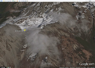
Did you know you can view historical imagery on Google Earth? Over time, a place may be imaged repeatedly for display on Google Earth. You may think that the currently displayed image is the best, but sometimes clouds can get in the way. To look at the Bimbi La, Tsari in Tibet, it is better to look at a historical view.
 |
| Current image of the Bimbi La on Google Earth |
 |
| Historical image of the Bimbi La on Google Earth |


Thanks!
ReplyDelete